
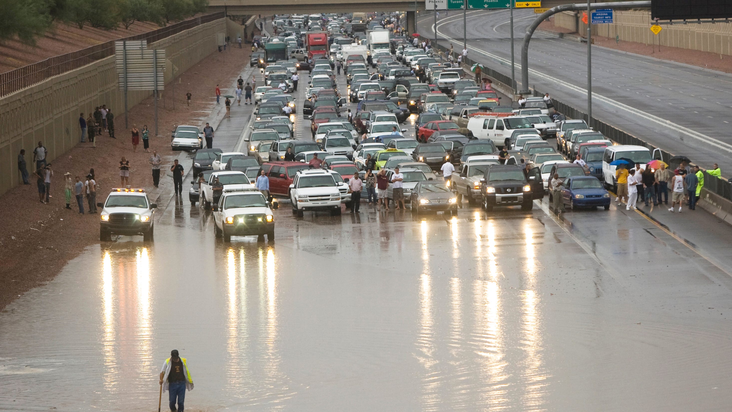
7 life-saving tips for driving in a monsoon storm
The monsoon in Arizona can produce fantastic sights but can also be dangerous. These tips can save your life if you’re on the road when a storm hits.
The Republic
The National Weather Service has issued severe thunderstorm warnings for Maricopa County starting at 3:25 p.m. July 25. The warnings expire at 9:30 p.m. July 25. The agency also issued a flash flood warning that started at 4:20 p.m. and would be in effect until 10:45 p.m.
Severe thunderstorms were located along a line extending from near Phoenix-Mesa Gateway Airport to Freestone Park, moving south at 10 mph; 60 mph wind gusts and penny-size hail were predicted.
Expect damage to roofs, siding, and trees.
Locations impacted included Mesa, Chandler, Gilbert, Tempe, Apache Junction, East Mesa, Queen Creek, Mesa Riverview Mall, Gilbert City Hall, Falcon Field Airport, downtown Mesa, Tumbleweed Park, Usery Mountain Park, Superstition Springs Mall, and Chandler City Hall.
This includes the following highways: U.S. 60 between mile markers 177 and 201; State Route 87 between mile markers 164 and 180; Loop 202 between mile markers 10 and 50.
Severe thunderstorms also were located along a line extending from near San Tan Mountain Park to 6 miles west of Blackwater to near Casa Grande, moving southeast at 20 mph; 60 mph wind gusts were predicted.
Expect damage to roofs, siding and trees.
Locations impacted included Mesa, Chandler, Gilbert, Casa Grande, Coolidge, Sun Lakes, Queen Creek, Blackwater, Chandler Heights, Tumbleweed Park, Magma, San Tan Village Mall, San Tan Valley, Seville, and Bapchule.
This included the following highways: Interstate 10 between mile markers 168 and 194; State Route 87 between mile markers 132 and 164; Loop 202 between mile markers 41 and 46.
Severe thunderstorms also were located along a line extending from 6 miles east of Wintersburg to 7 miles west of Painted Rock Dam to near Sundad, moving southeast at 15 mph; 60 mph wind gusts and penny-size hail were predicted.
Expect damage to roofs, siding and trees.
Locations impacted included Buckeye, Palo Verde, Painted Rock Dam, Liberty, Palo Verde Nuclear Generation Station, Sundad, Wintersburg, Hassayampa, and Arlington.
This included the following highways: Interstate 10 between mile markers 103 and 116; State Route 85 between mile markers 134 and 154.
A severe thunderstorm outflow was located along a line extending from east Mesa to near Superstition Springs Mall to near Apache Junction, moving southwest at 15 mph; 60 mph wind gusts were predicted.
Expect damage to roofs, siding and trees.
Locations impacted included Mesa, Chandler, Gilbert, Apache Junction, East Mesa, Gold Canyon, Queen Creek, Chandler Heights, Gilbert City Hall, Tumbleweed Park, Usery Mountain Park, Superstition Springs Mall, Chandler City Hall, San Tan Village Mall, and San Tan Valley.
This included the following highways: U.S. 60 between mile markers 182 and 203; State Route 87 between mile markers 165 and 169; Loop 202 between mile markers 23 and 47.
A severe thunderstorm also was located near Palo Verde Nuclear Generation Station, or 12 miles southwest of Buckeye, moving southeast at 5 mph; 60 mph wind gusts and penny-size hail were predicted.
Expect damage to roofs, siding and trees.
Locations impacted included Buckeye, Palo Verde, Painted Rock Dam, Palo Verde Nuclear Generation Station, Wintersburg, Hassayampa, and Arlington.
This included the following highways: Interstate 10 between mile markers 102 and 109; State Route 85 between mile markers 144 and 152.
A severe thunderstorm also was located over Saguaro Lake, or 9 miles south of Sugarloaf Mountain, moving southeast at 5 mph; 60 mph wind gusts and penny-size hail were predicted. Expect damage to roofs, siding and trees.
Locations impacted included Mesa, Apache Junction, Fountain Hills, Sugarloaf Mountain, Granite Reef Dam, Gold Camp, Lost Dutchman State Park, Goldfield, Usery Mountain Park, Saguaro Lake, Canyon Lake, Superstition Mountains, Goldfield Ranch, Kings Ranch, and Salt River Tubing Recreation Area.
This included the following highways: U.S. 60 between mile markers 192 and 202; State Route 87 between mile markers 187 and 204; Loop 202 between mile markers 23 and 29.
A severe thunderstorm also was located 11 miles northeast of Tonopah, moving southeast at 10 mph; 60 mph wind gusts and penny-size hail were predicted. Expect damage to roofs, siding and trees.
Locations impacted included Surprise and Buckeye. This included Interstate 10 between mile markers 107 and 110.
A severe thunderstorm also was located near Wickenburg, moving southeast at 5 mph; 60 mph wind gusts and penny-size hail were predicted. Expect damage to roofs, siding and trees.
Locations impacted included Wickenburg, Wittmann, Circle City, and Morristown.
This included the following highways: U.S. 60 between mile markers 107 and 128; State Route 74 between mile markers 1 and 10.
A severe thunderstorm also was located near Roosevelt Dam, or near Roosevelt, and is nearly stationary; 60 mph wind gusts and penny-size hail were predicted. Expect damage to roofs, siding and trees.
Locations impacted included Roosevelt, Roosevelt Estates, Roosevelt Dam, Apache Lake, and Tonto National Monument.
This included State Route 188 between mile markers 225 and 249.
Future forecast: 2024 monsoon season has been wetter than expected. What can Arizona expect in August?
For the latest watches and warnings, see our weather alert page.
Tips for driving in the rain
The Arizona Department of Transportation provided the following safety tips for driving in the rain:
- Inspect windshield wipers and replace them if necessary prior to expected rainfall.
- Turn on the headlights.
- Reduce speeds.
- Avoid sudden braking on wet pavement.
- Create a “space cushion” between your vehicle and the vehicle in front of you.
- Avoid areas where water has pooled in travel lanes.
Tips for flood weather
Coconino County officials offered the following tips for residents to prepare for approaching storms and potential flooding threats.
- Protect your property from floodwaters and purchase flood insurance.
- Plan for sheltering where you are and for evacuation.
- Evacuate if advised.
- Seek high ground (for flash floods) or stay on high ground.
- Avoid walking or driving in floodwaters. Depth and velocity of the water are not always obvious; the ground or road may suddenly wash away and hidden dangers may exist; do not attempt to evacuate through floodwaters.
- Know how to avoid injury from debris, contaminated water, carbon monoxide poisoning, electrocution, and damaged buildings and infrastructure.
- Seek professional review or inspection of structures and utilities before entering buildings that are flooded.
How to protect yourself from lightning strikes
Here are lightning safety tips from the National Weather Service:
- Pay attention to the weather. If you see big blue clouds, otherwise known as thunderheads, go inside. These types of clouds could mean a thunderstorm is coming.
- Get in a building with plumbing and wiring. If lightning strikes the building, the lightning will be conducted around and into the ground.
- Stay in your car. A vehicle will give you protection as electricity from lightning will pass through the vehicle’s structure instead of hitting you.
- Get off open water. A boat out on the water is likely to be the most prominent object and you could be struck.
- Do not shower or bathe. If lightning hits your pipes, it could be conducted into the water in your bath or shower.
- Do not use electric appliances with plugs or cords. Wireless cellphones are OK, as are laptops that are connected to Wi-Fi but not plugged in.
- Follow the 30-30 rule. If you hear thunder within 30 seconds of a lightning bolt, that means the thunderstorm’s distance is threatening. Wait at least 30 minutes after you hear the last thunder to go out. That gives the storm enough time to move away or dissipate.
- You don’t have to be near a storm to get struck. Lightning strikes can easily travel 10 miles or more. A record lightning flash in Oklahoma in 2007 traveled nearly 200 miles. Seek shelter if you hear thunder.
- Do not shelter under a tree. If lightning strikes the tree, the ground charge from the strike could travel into you.
- Don’t huddle in a group. If you are outdoors with friends or family during a thunderstorm, don’t all clump together. Keeping separation could reduce the number of people injured if lightning strikes.
This article was generated by The Arizona Republic and USA TODAY Network using data released by the National Weather Service. It was edited by a staff member.