
SAGINAW, Mich. (WNEM) – Clouds have already arrived foreshadowing the storm potential later today. We’re continuing to track showers and thunderstorms for the afternoon and evening so if you have anything you want to do outdoors that requires dry weather, take advantage of the early afternoon!
More details on today are below, but to quickly touch on the rest of the week the only other main chance of rain is on Thursday. Wednesday just sees an isolated shower. As of this morning though, that shower chance on Thursday is starting to back away to the south more. You can see more of a snapshot of the rest of the week in your full TV5 First Alert 7-Day Forecast!
Today
Temperatures will warm up to the upper 60s by noon, then into the lower 70s near 3 PM just before the first line of showers moves in. Wind speeds today will range from 5 to 15 mph, then with gusts to 20 mph in the afternoon. Most of the day our wind will also be southeasterly.
We’re expecting two main rounds of rain today. The first round will be a line of steady showers moving northeast starting around 3 PM. This will last until around 5 PM. There is no severe weather threat present with the first line of showers. It’s going to be driven by a warm front though, so behind it expect higher humidity values and rather than a large drop in temperatures, numbers staying steady in the middle to upper 60s.
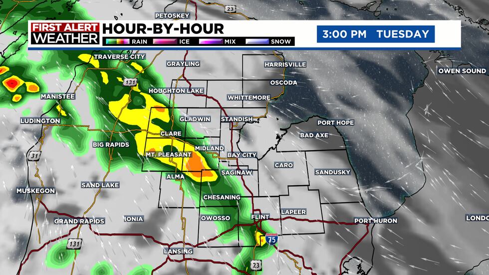
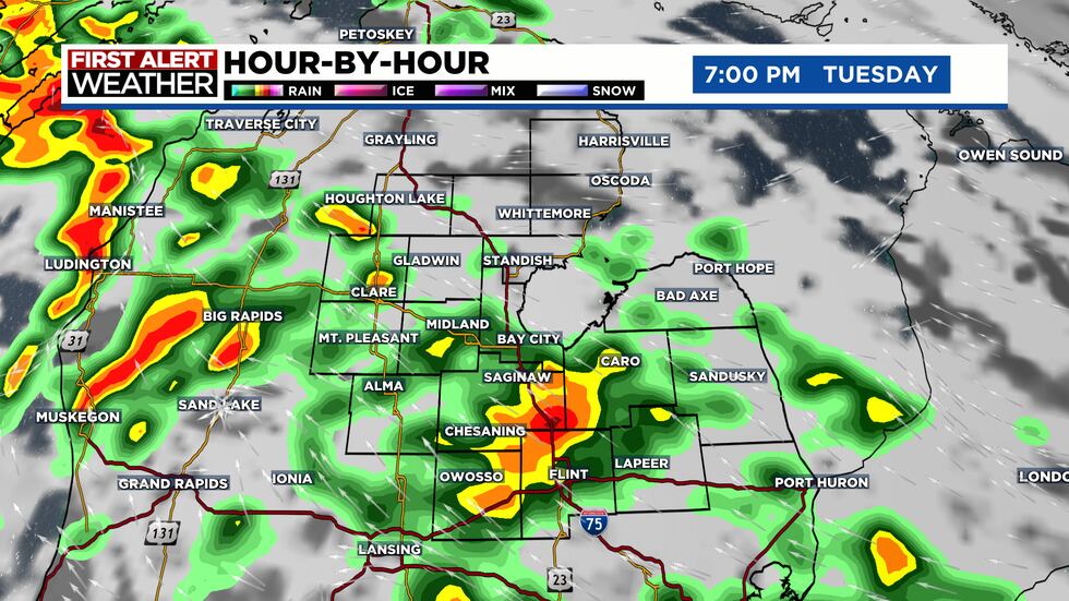
The second round of rain is where more thunderstorms develop, along with the risk of severe weather. We expect storms to more-so be in clusters than a line, with activity holding on all the way up until around 11 PM. Notice below some of the stronger cells within the clusters in the snapshot of the First Alert Hour-By-Hour.
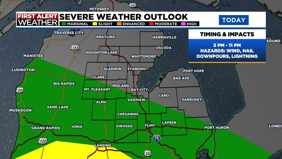
Our severe weather risk is still relatively low, but something that can’t be ignored today. As always, we want you to stay weather aware and have a way to receive weather alerts such as with the TV5 First Alert Weather App. We’ll be closely monitoring storms too as they form later today. The Marginal Risk for severe weather has shifted slightly farther north since yesterday too. Now, the risk area extends from around Rosebush to Freeland and Saginaw, then south over Birch Run, Otisville, and Lapeer. Wind and hail are going to be the two primary threats today. Although the chance is highly unlikely, there will be some spin present in the atmosphere this evening so we can’t forego some possibility of a brief, isolated tornado. The timeframe of severe weather potential is 5 PM to 11 PM.
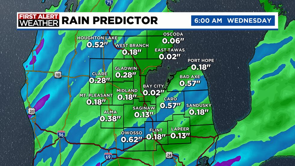
Rain totals today will range anywhere from 0.1″ to 0.5″. The higher end of that range is under thunderstorms, while the lower end will be for anyone who picks up the first round of showers, but then dodges any storms in the evening.
Tonight
Other than a few lingering showers and thunderstorms before midnight, the rest of the night will be dry with skies turning partly cloudy. Lows will settle down to 54 degrees with the wind shifting from the southeast to the southwest with a speed of 5 to 15 mph.
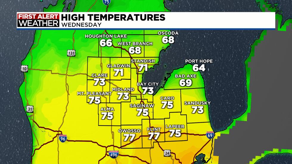
Wednesday
Skies will stay partly cloudy all day with highs reaching 75 degrees. We’re giving you the First Alert to breezy conditions though, expect a west northwest wind at 10 to 20 mph, gusting to 30 mph. Other than a stray, pop-up shower, the day will stay dry.
Copyright 2024 WNEM. All rights reserved.