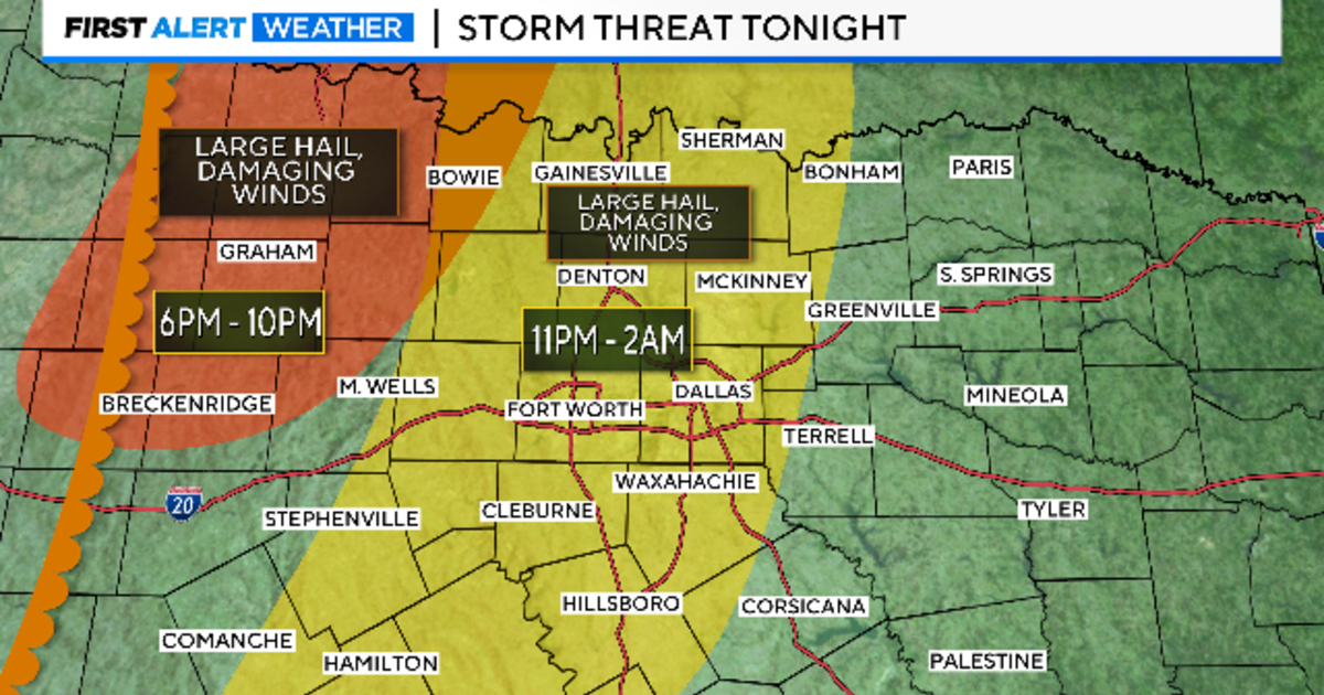
NORTH TEXAS — A weather alert is in effect for Sunday night beginning at 7 p.m. and continuing into Monday morning.
The severe weather threat includes damaging wind and large hail. The tornado risk is not zero.
There is a Thunderstorm Watch that includes Tarrant and Dallas counties in effect until 3 a.m.
The Storm Prediction Center pushed the “slight” risk (yellow) area into the metroplex Sunday afternoon with the forecast model updates. We are expecting the severe threat to show up late Sunday night.
The threat increased due to a strong upper-level wind coming in from the west earlier than forecast. This was the little extra lift needed for these storms. Large hail and damaging winds will be the main threat. Already Sunday afternoon, a Thunderstorm Watch is in effect until 9 p.m. just at our western edge.
These storms are along the dryline and are racing to the northwest late Sunday afternoon producing large hail. Some of our northwest corner is under risk Sunday evening from this activity. That’s the area in red below.
The area in yellow that includes the metroplex is a threat from a cold front that arrives sometime around midnight, give or take an hour. These storms could produce hail and damaging winds. The tornado risk is very low but not zero.
The line should fill out overnight. Then the main threat will be damaging winds. There is a low chance for a quick spin-up weak tornado along the leading edge with these storms.
We are expecting these storms to be across our eastern counties by daybreak. They will have weakened but still produce a good rain with some lightning.
Monday, we expect southwest/west winds and a high in the low 70s. Get out and enjoy the lunch hour.
Clouds come back in the afternoon as another cold front comes in, this one from the north with cooler air. A few quick showers are possible at close of day.
This is the best chance for some spring rain in the week ahead.
There is a small chance for storms on Wednesday afternoon, mostly in our western half. Great weather for the Rangers home opener on Thursday, maybe they’ll have the roof open! Otherwise, expect some cooler mornings this week as we count down to Good Friday and Easter.


