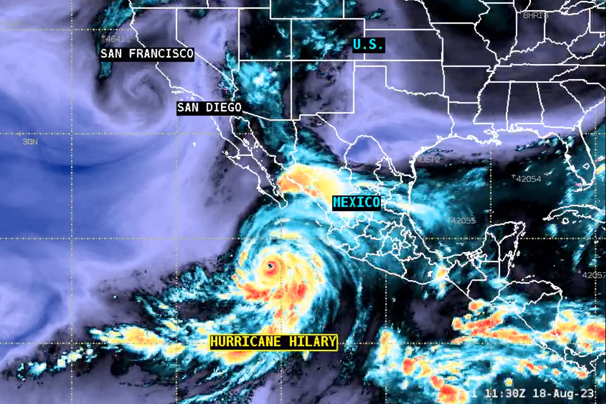
Satellite image showing Hurricane Hilary on Aug. 18, 2023.
National Weather Service
Hilary intensified to a Category 4 hurricane on Friday, meaning its winds are 130 mph and over. While the system is expected to start weakening Friday night, it’s likely to reach land in the northern Baja California peninsula on Saturday as a hurricane. The system will likely continue to lose intensity as it approaches California’s cooler waters and air mass, and when its center reaches Southern California, expected to happen Sunday night into Monday morning, it will likely be categorized as a tropical storm.
Advertisement
Article continues below this ad
Heavy rainfall and flooding is expected to begin impacting Southern California from Hurricane Hilary on Saturday, well in advance of the center passing over the state. Peak impacts in Southern California are expected Sunday into Monday, with desert areas, including Palm Springs, likely to see some of the most severe flooding.
“This is an event that could produce once in a century of rainfall” in some parts of the deserts of southeastern California, said Daniel Swain, a climate scientist at UCLA. Swain said the potential for historic flash flooding is high in places such as Death Valley, the Mojave Desert, Palm Springs, Coachella Valley and the Antelope Valley.
For the first time ever, the National Hurricane Center issued a tropical storm watch for portions of Southern California. Damage to homes, fallen trees, impassable roads and power outages are among the impacts possible in areas under the water. The storm system could also spawn tornados capable of tearing off roofs and blowing cars off roads.
“From San Diego north to the Orange/LA County line, Southern California residents are under their first tropical storm watch since hurricane products were introduced in the 1950s,” meteorologist Bob Henson wrote on social media.
Advertisement
Article continues below this ad
Swain shared live satellite footage of Hurricane Hilary on Friday in a forecast update on the storm. “This is a fairly extraordinary image,” Swain said.
As a Category 4 hurricane on Friday afternoon, Hilary was getting closer to southern Baja California and is expected to take a north turn and ride up the western coast of Baja California.
“This is unfortunately going to rake the Baja Peninsula pretty severely,” Swain said.
Ensenada and Tijuana could see significant impacts, as well as the eastern side of the Baja peninsula. Hurricane landfalls are unusual on the west and the northwestern part of Baja’s peninsula.
Advertisement
Article continues below this ad
Swain said there was indication that Hilary might intensify again before it weakens. Warm water fuels hurricanes, and the temperatures in the Pacific Ocean off Baja California are warmer than usual for this time of year.
“It appears that it may even be putting on one last burst of strengthening and trying to make a run at Category 5 status, which would be very impressive, although not unprecedented,” he said.
As the system nears California’s cooler waters Sunday into Monday, it is expected to lose intensity rapidly and reach Southern California as a tropical storm. It’s very unusual for tropical storms to make land in California as these systems usually fizzle out.
“The difference from the typical situation is it’s so strong right now, and it is going to move so quickly, making a beeline for Southern California, it simply isn’t going to have time to fall apart nearly as much as these systems usually do before they reach California,” Swain said. “So for this reason, it is now likely that for the first time since 1939, the year of the Long Beach tropical cyclone, a tropical cyclone at tropical storm strength or greater will likely make landfall in or near Southern California, late Sunday or early Monday morning, potentially in the overnight hours.”
Advertisement
Article continues below this ad