
CEDAR RAPIDS, Iowa (KCRG) – Storms are possible overnight tonight and a few storms could become strong to severe.
Your First Alert: More scattered storms to come, some could be strong
The latest satellite and radar data.
(KCRG)
Look for a gradual increase in the number of showers and storms this evening. The highest chance for widespread rain will be along and north of U.S. Highway 20 tonight, but just about anybody could see a storm during this active timeframe.
Hail or damaging winds are the primary threat if any storm turns severe. A spin-up tornado may develop if things come together just right. Due to this low, but still present, potential, we encourage you to stay weather-aware throughout the day. Get the KCRG First Alert Weather app on your smart device and have your notifications on, along with making sure that your NOAA weather radio is turned on and ready to receive potential watches or warnings.
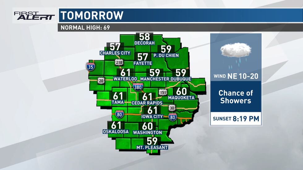
Lows tonight dip into the low to mid-50s as cooler air begins to move in. Winds will shift to the east, and then north as we go through the night. Showers and a few embedded storms will continue at times on Thursday, moving slowly from our northern zones to the south. A few more showers could pop up in the wake of this initial area, keeping the chance going into the afternoon.
Highs tomorrow will be limited by more widespread cloud cover, along with the rain that we may see.
Mostly quiet toward Mother’s Day weekend, with a warming trend
Shower activity comes to an end by Thursday evening, leaving behind partially clearing skies. A light northwesterly wind will continue to pull in chillier air, with most areas headed for the low 40s for lows. A couple of spots in the north could slip into the upper 30s, especially in low-lying areas like river valleys.
A mix of sun and clouds appears probable on Friday, with slightly warmer temperatures than Thursday. Highs head for the low to upper 60s from north to south, which is near or just a couple of degrees below normal for this point on the calendar. This also is the first sign of a warm-up that will last for the next few days to follow.
On Friday night, a quick-moving disturbance will pass through the Great Lakes region, carrying a chance for some showers with it. The TV9 viewing area will be on the far southwest periphery of this area but should be close enough that a few areas will see a brief sprinkle or shower. Any rainfall would stay quite light.
Drier weather looks likely for much of Saturday and Sunday, as highs continue to push into the 70s. Mother’s Day itself looks like it should be pretty decent, with above-normal temperatures and plenty of opportunity to get out and about if you have plans with Mom.

Your First Alert: More opportunities for showers and storms next week
After a break from more active weather for a few days, the chance for more precipitation returns as soon as Monday. A frontal boundary will be near the state at times, providing the focus for the occasional development of showers and storms.
The chance is slight on Monday at this point, with an increasing threat of showers and storms toward the middle of next week. Things may reach a bit of a peak in terms of rainfall potential on Wednesday as an area of low pressure tracks through the region.
Temperatures next week look to stay on the warm side, with highs in the mid to upper 70s for many.
Copyright 2024 KCRG. All rights reserved.