Torrential rain continues to fall across portions of Texas on Thursday, forcing officials to issue mandatory evacuation orders due to flooding.
HOUSTON – A life-threatening situation continues to unfold across portions of Southeast Texas on Thursday as torrential rain and severe weather pounded the region, causing rivers and streams to overflow their banks, flood numerous communities along the Trinity and San Jacinto rivers and trigger urgent evacuations.
(FOX Weather)
That region of Texas has been pounded by relentless rain since Sunday, with rain gauges near Trinity reporting 6-9 inches and Groveton picking up nearly 11 inches of rain from a round of storms at the end of last weekend and into the start of the workweek.
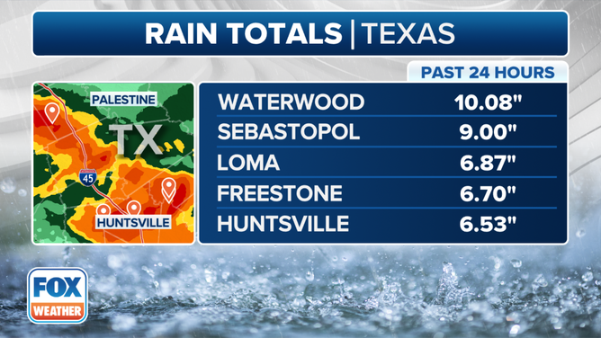
This graphic shows rainfall totals over the past 24 hours.
(FOX Weather)
Multiple Flash Flood Warnings were in effect Thursday for several Texas communities as more precipitation fell across many of the same areas Tuesday and Wednesday, only adding to the epic rainfall totals.
Waterwood picked up more than 10 inches of rain Wednesday, and Sebastopol wasn’t far behind with 9 inches.
Many other areas picked up more than a half-foot of rain, including Loma, Freestone and Huntsville.
FOX 26 Houston Reporter Shelby Rose said Wednesday that eight people and 23 dogs needed to be rescued from their homes in Harris County – the most populous county in Texas.
Harris County urges some to evacuate
FOX 26 Houston Reporter Shelby Rose joined FOX Weather on Thursday morning and says Highway 59 in Livingston is impassable due to major flooding that has been reported due to relentless rain that has been falling across portions of the state.
Voluntary and mandatory evacuations have been ordered in several neighborhoods along the Trinity and San Jacinto rivers in Texas, and schools have been closed across the region.
The situation has become more dire along the East Fork of the San Jacinto River, where officials are declaring mandatory evacuations along the eastern side of the fork.
“There was a lot of rain north of (Houston) (Wednesday) night and over the last couple days, and that’s going to have some really severe impact for folks,” said Harris County Judge Lina Hidalgo. “It’s turning out especially for the east side of the San Jacinto River to be worse than we imagined.”
The mandatory evacuations run from FM Road 1485 to Lake Houston, and Hidalgo warned flooding impacts may stretch as far as a half mile inland from the river banks.
“This is different than what happened Tuesday,” Hidalgo said. “This is significantly higher water, which is going to impact mobility and your ability to take care of yourself and your family. We want you out of this area. We can’t force anyone to do anything, but this is a life-threatening situation.”
Hidalgo said the river normally flows at 45-50 feet but was up to 70 feet Tuesday as more water surged in from upriver – with floodwaters covering up to the top of stop signs. What’s worse, forecasts indicate the river will rise another 8 feet starting Friday – to just 3 feet below the devastating floods of Hurricane Harvey in 2017.
“That means elevated structures will get water … it means the water will be hitting power lines, which puts our emergency evacuation vehicles at risk because they’re not going to be able to see those power lines,” Hidalgo said. “Please evacuate that area as soon as possible.”
Mandatory evacuations ordered in San Jacinto County due to flooding
High-water rescue trucks rolled into communities in San Jacinto County on Wednesday, and despite the danger and pleas from officials to evacuate, some people are refusing to leave their homes.
“I think that’s one of the biggest problems we’re going to face is the fact that some of these people do not want to abide by that evacuation order,” Huffman Volunteer Fire Department Chief Tyler Shirley said. “The first rescue we had tonight was exactly that scenario. An individual that wanted to stay and realized that the water was going to rise a lot quicker than he thought. And we ended up having to go back out there after him.”
Shirley called the flooding unprecedented based on how fast the waters rose.
The life-threatening situation appears to have gotten worse in the area, and that has led to officials in San Jacinto County also issuing a mandatory evacuation order for residents living in the unincorporated areas of the county, below the Lake Livingston Dam and along the Trinity River.
Heavy rain has caused rivers to overflow their banks in parts of Texas, forcing officials to ask people in neighborhoods along the Trinity River and San Jacinto River to leave their homes until water recedes.
Residents have been told to seek shelter with family, friends or at a hotel, but shelters are being opened if that isn’t an option.
Montgomery County residents told to evacuate to higher ground immediately
The Montgomery County Office of Homeland Security and Emergency Management issued an urgent message on Facebook on Thursday warning residents living along the West Fork of the San Jacinto River south of the Lake Conroe Dam to take immediate precautions due to a significant rise in river levels as water is released downstream.
According to the Facebook post, the San Jacinto River Authority (SJRA) has increased the release to 66,100 cubic feet per second, and downstream flooding was imminent.
“All residents downstream along the West Fork of the San Jacinto River should immediately begin evacuating to higher ground,” officials warned.
RELENTLESS SEVERE STORMS CONTINUE TO TORTURE AREAS FROM TEXAS TO UPPER MIDWEST ON THURSDAY
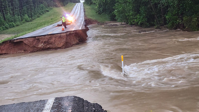
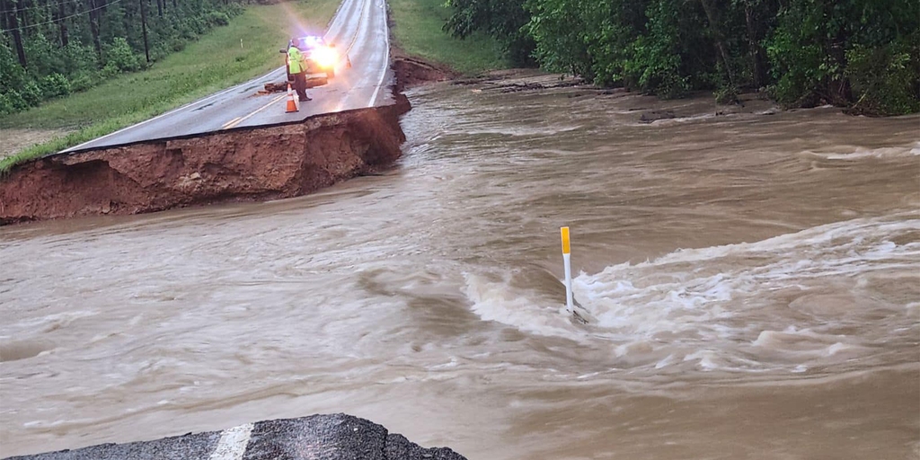
This image shows a road that was washed away by raging floodwaters in Walker County, Texas, on Thursday, May 2, 2024.
(Walker County Pct 4 Commissioners Office)
More heavy rain in the forecast for Friday
Flood Watches remain in effect for portions of Texas and Louisiana into Friday afternoon as additional rain and severe weather is expected to pummel the region.
“That same area is getting pounded right now, so it’s a huge concern,” said FOX Weather Meteorologist Britta Merwin. “That’s why the Flood Watches are up. It’s not only because of the flash flood concern – how much is falling out of the actual sky – but everything that’s filtering down the system.”
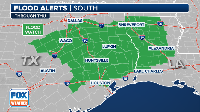
This graphic shows active flood alerts on Thursday, May 2, 2024.
(FOX Weather)
Houston is among the Texas cities included in the Flood Watch, as well as Waco, Lufkin and Huntsville. A large portion of western and northern Louisiana, from Shreveport through Alexandria and into Lake Charles, is also on alert.
Most areas of East Texas can expect to see an additional 1-2 inches through the rest of the week. But a large area in Southeast Texas will continue to see heavy rain that will push expected rainfall totals much higher.
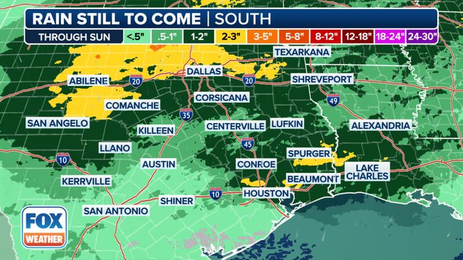
This graphic shows the forecast rain totals through Sunday, May 5, 2024.
(FOX Weather)
About 2-3 additional inches could fall north and west of the Dallas area, with some higher amounts of 3-5 inches also possible.
Areas to the north and east of Houston could also see rainfall totals between 2-3 inches through the end of the week, with some communities seeing an additional 3-5 inches.
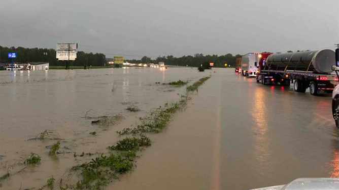
This image shows traffic at a standstill due to flooding in Lufkin, Texas, on Thursday, May 2, 2024.
(@TXDOTLufkin/X / FOX Weather)
The flood risk will continue across the area through at least Sunday, when conditions are expected to improve.